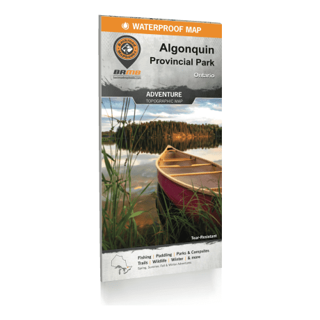
Backroad Mapbooks - Algonquin Provincial Park Ontario Waterproof Map
Article # C: 298094 B: 3387106
Share:
Product Description
• Printed on durable, waterproof, tear-resistant material
• Industry leading cartographic detail and state-of-the-art relief shading
• Close collaboration with government sources and local outfitters makes this the most up-to-date and accurate map available for Algonquin Park
• Large-scale 86 cm x 117 cm (34" x 46-1/4") map is easy to read
• Detailed park regulations, fees, resources and emergency contact numbers
• Updated stocking chart for brook trout and splake
• Updated sportfish species labelled on the maps
• Paddling chart with 30 different canoe routes
• Official and unofficial interior canoe access points
• Paddle-in campsites designated as low or high use
• Portage trails labelled with distance and designated as low or high maintained
• Easy to see and identify backpacking trails
• Updated Trail chart with distance, difficulty and activity type
• Winter trails including cross-country ski, fat biking and snowshoe trails
Spanning 7,653 km² (2,955 mi²), Algonquin Park is both one of Canada’s largest provincial parks and one of its most popular. Sprawling forests of red and white pine surround an endless patchwork of pristine lakes, dotted with secluded paddle-in backcountry campsites never too far away. Moose pick their way through the brush with surprising agility, while beavers cut across the lakes’ glassy stillness. Trout and walleye swim the lakes and rivers in abundance, attracting anglers from far and wide. Whether you are planning to canoe, kayak, backpack, camp, fish or do it all, this is your ultimate guide to outdoor adventure in Algonquin Park, from the Barron Canyon to the Highway 60 Corridor and from the East Gate to the West Gate.
Backroad Mapbooks’ industry-leading waterproof maps are the most detailed, comprehensive and up-to-date recreation maps available on the market, making them the maps of choice for recreation, industry and search-and-rescue. With numerous updates from our last edition, including labelled fish species, there has never been a better way to pack so much recreation information right in your front pocket.
Backroad Mapbooks’ industry-leading topographic maps are the most detailed, comprehensive and easy-to-use recreation maps available on the market.
Our Algonquin Provincial Park Ontario Waterproof Map includes:
• Easy-to-read, large-scale dual-sided 86 cm x 117 cm (34" x 46-1/4") map derived from our Backroad Mapbooks
• A two-in-one map, covering the entire park on one side with up-close details of the Highway 60 Corridor on the other
• The most complete canoe route, hiking trail and road coverage available for Algonquin Park
• Waterproof, tear-resistant material that can withstand all that Mother Nature can throw at it
• Countless land and water geographic features
• Labelled fish species and stocked lakes for anglers
